The following is a reproduction of the “Corinella Sesqui-Centenary Celebrations” publication prepared by the ‘Settlement Point 150 Years Celebration Committee’ in 1976.
This publication acknowledges and expresses gratitude to the Reverend Jim Brown – Mirboo North, who compiled and wrote this history of Western Port.
BEFORE THE BEGINNING – THE DREAM TIME
This is an odd way to commence a story, but it is fascinating how people refer back only to the beginning of white exploration and pioneering, when the subject of local history is broached. Thrilling and Intrepid as the stories of early settlement may be, the story goes a long way further back, to a nomadic race of people with strange ways and customs, who had the ability to blend and live with their environment, who were at heart a peace-loving people, and who were so terribly misunderstood by the early white settlers.
“A truly savage race can have nothing that we may narrate as history” is how one early writer commenced his article about the Aboriginal Era in Southern Victoria; and the article was full of contempt for the “sable predecessors” to the coming of the white settler.
The aborigines of Western Port were part of the great Bunerong (sic) Tribe, and in 1837 they numbered about 6,000 around the shores of Western Port and on the Mornington Peninsula. John Aitken told Governor La Trobe of his experience with them in 1836: “On landing at Arthur’s Seat they were most friendly, assisting us to land our sheep. About 80 was the number that I then saw, being the Western Port tribe, some of whom accompanied me on my journey around the Bay to Melbourne. Sealers who had lived and worked near aborigines on Phillip Island in 1826, described them thus: “They had been on terms of friendly intimacy with the natives, found them amiable in their disposition, and with a prepossessing outward appearance. Indeed a fine muscular and well proportioned race.” These were the people who were so numerous in 1837, but by 1891 their number was down to 300. What took toll of these hardy people? The destruction of their environment as land was cleared for settlement, the easy access and unsuitability of white man’s food, the introduction of tobacco, alcohol and white man’s diseases. The lack of understanding of kindly people who tried to impose western civilisation on them and succeeded in destroying their heritage, and the general cruelty of many of the white settlers, led to violation of the native women and to murder. By 1900 this once amiable tribe was completely obliterated – a sad indictment of our early pioneers – and even the corroboree rings and the mud ovens are long since gone. All that remains are some stone implements and weapons, a few of their legends and a legacy of place names from their musical language, to server as an enduring memorial to their thousands of years of occupation: Corinella (kangaroo), Yallock (water or creek), Warneet (river), Tooradin (the demon of the swamp), Gardinia (sunrise), Koo-wee-rup (swimming black-fish), Lang Lang (clump of trees), Monomeith (good and beautiful), Yannathan (to walk).
THE BEGINNING – DISCOVERY BY ACCIDENT
The beginning was with Surgeon George Bass and his six intrepid sailors in their 28 feet long whale-boat. On 2nd January 1978, they had discovered Wilson’s Promontory (named by Bass) and Bass directed his boat south towards Tasmania, as he thought that he was in a wide bay. That night, a storm blew up, and the wild stormy seas forced him back to the Victorian coast, where he was forced to wait until the seas abated. He resumed his journey along the Victorian coast and discovered and entered Western Port by the eastern passage in the evening of 5th January.
Western Port was named by Bass “from its relative situation to every other known harbour on the coast”. The party sailed along the river which now bears his name, looking for water. They they found at the site of the present township of Bass, and they stayed for a period of twelve days repairing the boat, replenishing supplies and exploring. Bass explored the west side of Phillip Island on foot, but he was not aware of the existence of another large island, as he assumed French Island was part of the mainland. He left the bay, again using the eastern passage, departing on the 18th January. In his journal he noted that the country seemed to be in the grip of an unusual drought and that fresh water was difficult to find.
AFTER THE BEGINNING
Because of the comments of Bass in his journal about the seals around Phillip Island, the wild lawless era of the sealers began, mostly on Phillip Island and lasted 40 years. It was a haven for escaped convicts, who stole women from the aborigines and settled their differences with violence. The waters around the island were almost completely fished out of seals, and the era came to an end with the coming of the members of the McHaffie family in 1842, who secured the right to use the Island as a sheep run.
After Bass, a French scientific expedition under the leadership of Captain Nicholas Boudin used Western Port as a haven in 1800. Sailors from one of the boats, ‘La Naturaliste”, in charge of Captain Hamelin spent eight days exploring the bay, and they sailed around French Island, commemorating their visit by giving it that name. The presence of this expedition gave rise to the fears that waxed and waned for many years, the the French intended to settle and establish a convict settlement on the southern coast.
In March 1801, Lieut. James Grant was commissioned by Governor King in Sydney to explore and examine Western Port, with a view to the establishment of a new colony. This was the first task of the new, but unusually designed vessel, “The Lady Nelson” which was to play a major part in the exploration of Victoria and the southern waters for the next twenty years. It was designed by Captain Schank of the Admiralty, for the exploration in shallow waters and had what was known as a sliding keel, and a weight of sixty five tons. Lieut. Grant sailed “the Lady Nelson” from England to Sydney, and was the first to sail through Bass Strait from west to east.
Grant entered Western Port by the western passage and stayed for 33 days exploring the various islands and the mainland, and his surveyor Barrellier, was soon charting fresh discoveries. Barrelliers map was the first to show French Island as an Island. Churchill Island was named by Grant after John Churchill of Dawlish, a benefactor who had supplied him with a quantity of seed of both fruit and vegetables before he left England. Ground was prepared on Churchill Island and wheat, onions, potatoes, cucumbers, pumpkins, and melons were sown. He even tried to grow apples, plums, peaches, rice and coffee. A log cabin was built, 24 feet long and 12 feet wide, the first white man’s structure on Victorian soil. Barrelliers map showed Phillip Island as Snapper Island and it was first referred to as Phillip Island in a letter sent by Governor King to the Duke of Portland in 1802.
Grant was impressed with Western Port and he considered that it would make a good naval base. His report on the country side gave a picture of coastal land, thinly wooded with timber in some place, but often thickly covered with dense brushwood; though in many places there were circular open spaces of rich grassy land, where cattle could easily fatten. Further back on the surrounding hills, the trees grew larger and were a veritable forest.
In December 1801, Lieut. John Murray became the commander of the “Lady Nelson” and he was sent by Governor King to make fresh investigations of the Victorian coast. Murray sailed in Western Port on the 7th December, and owing to bad weather, he was forced to stay for a month. He found that Grant’s garden on Churchill Island was flourishing, and there was a fine crop of wheat; but he was not favourably impressed with Western Port, considering the soil too light and sandy for settlement, and fresh water was a problem. He continued to explore the coastline in Bass Straight, discovering and later entering Port Phillip Bay, which he named Port King. This was later changed by Governor King to Port Phillip Bay.
After the abortive attempt at settlement at Sorrento in 1803 and the eclipse of French naval power at Trafalgar, the fears of French settlement in Australia were allayed, and for nearly 20 years the Victorian coastline was officially ignored. There was no activity apart from that of the sealers and whalers.
THE FRENCH ARE COMING – LET’S BUILD A FORT.
In 1826 the ominous word came from England, “The French are coming”. This aroused the old fears that the French once again had designs on settlement in Australia, and in correspondence with London, Governor Darling recommended that his commission should extend over the whole of Australia instead of being limited to the eastern half. He was given permission from London for the immediate establishment of four settlement; on the Brisbane River, at Melville Island, on King George’s Sound, and at Western Port.
Western Port was chosen as the site for settlement because of the favourable accounts of the surrounding country, brought back by Hume and Hovell, who had the mistaken view that they had reached the shores of Western Port on their recent overland journey from New South Wales in 1824. Hovell was requested to go with the expedition and act as a guide, a position which he gladly accepted; thus two mistakes led to the establishment of this settlement. Hume and Hovell’s favoutrable impression of the land which they had mistaken for Western Port, and the belief that the French scientific ship “La Astrolabe”, under the command of Captain d’Urville, had other interests in our southern regions.
Captain Wright of the 3rd Buffs Regiment was selected as Commandant, with Lieutenant Burchill as his assistant. Under his command was placed a detachment of soldiers and 21 convicts, as well as a number of civilians, including Hovell. A small brig “Dragon” was loaded with six months supplies, and escorted by the “H.M.S Fly”, under the command of Captain Wetherall, left Sydney Harbour on the 9th November, 1826, accompanied by the brig “Amity” with Major Lockyer in command. This smaller party was destined to proceed to King George’s Sound to establish a settlement there.
The weather was wild, the journey to Western Port took 16 days, and it was not until 25th November that they established themselves on Phillip Island, near the present township of Rhyll. A sealer, John Scott, informed them that the “Astrolabe” had been in the bay for seven days and had departed for Sydney a week previously. The two parties had unknowingly passed each other in Bass Strait.
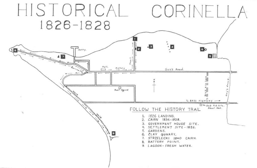
Wright chose a commanding, flat-topped hill, about four acres of land were cleared to form Fort Dumersq and two six pounder guns were landed. Wells were dug for water, and a road was commenced across the Island, the first military road in Victoria, in expectation of the discovery of coal on the south side of the Island. However the Island was considered unsatisfactory for settlement by reason of the scarcity of water. After careful exploration of the bay, Wright, in consultation with Wetherall, decided to move his little settlement to a strategic point on the eastern side of the bay, one mile east of the present township of Corinella.
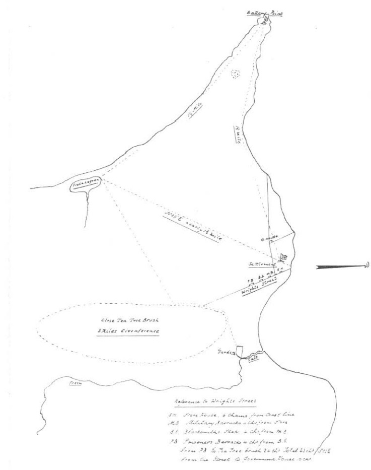
Plan of the settlement from the Public Record Office, London. Wright Street showing positions of storehouse, military barracks, blacksmith’s shop, and prisoner’s barracks – from right to left.
Great care was taken in choosing the new site, for this was to be a permanent settlement and it was expected that free settlers would soon be attracted to the surrounding country, which had been described so favourably by Hume and Hovell. Work began immediately in preparing the new site; scrub was cut and burnt, trees were felled, land cleared, tents were pitched, stock was landed; and a formal possession was taken on the 12th December, 1826. The day after the completion of the landing, on the 27th December, the “Dragon” and “H.M.S. Fly” sailed for Sydney, with Captain Wetherall taking to the Governor a favourable report of the new site for the settlement. He wrote: “I do not hesitate to pronounce this one of the most inviting and fertile spots which a person could expect to find in a Country as yet in a state of nature.”
Captain Wright was not so hopeful. It was soon obvious that the fine land to the north of Western Port described by Hume and Hovell did not exist; instead it was a huge swamp. Another problem was that of extensive mud-flats and sand-banks at low tide, which prevented vessels from laying close in-shore. Then there was the real problem of the lack of a good supply of fresh water but he consdiered that this would be overcome in time. In his report to the Colonial Secretary, he stated that there was only a comparitively small area of good land in the neighbourhood of the Settlement, and that the land further afield was generally sterile, swampy, and impenetrable. He had formed the opinion that it did not posses sufficient scope for colonisation on a large scale.
The work of establishing the settlement started immediately and discipline was strict. The prisoners worked twelve hours a day and the use of the cat-o’-nine tails ensured that the work went on at a great pace, despite the Summer heat and Winter cold. A saw-pit was dug at the Bass River, and 500-600 super feet of scantling was cut each week from the local timber. Good quality clay was available, and thousands of bricks were readily produced; and it was not long before the settlement began to take shape. The carpenters split thousands of shingles from the numerous she-oaks growing at the Point, but until sufficient shingles were available the first buildings were temporarily thatched with long dry grass. The first serious setback to the building programme occurred when a spark from the black-smiths’s fire ignited a pile of grass collected for thatching, and in less than ten minutes the prisoner’s brarracks and an overseer’s hut were burnt to the ground. By the end of March, the Commandant’s house (Government House) was complete with a brick chimney and a shingled roof, and the prisoners were rapidly building themselves two new barracks to replace the original one destroyed by fire. There was a hut for a hospital, a shepherd’s hut, a sentry box, and stockyards, and a road was constructed across the creek where water was obtained. Water was a real problem which was never overcome during the life of the settlement. Two and half acres were set aside for a vegetable garden, and potatoes, carrots, beans, radishes, pumpkins, and cabbages, were sown, and most of the vegetables grew well. Nearby, land was cleared for crops and broken with the plough, and wheat, oats, and maize were planted.
EXLORATION WITH HOVELL – A MISGUIDED GUIDE
Hovell lost no time in exploring the surrounding countryside; he was well equipped for exploration and three convicts had been assigned to assist him. On the 16th December 1826, he left on the first of fiuve short journeys, travelling south and east towards Cape Paterson, and it was on this trip that he discovered coal at the Cape. There were three seams about ten inches thick running parallel for about two mile and he returned to the “Dragon” on the 23rd December with a sample of the coal, which was sent to Sydney.
On the 2nd January 1827, he left on a week’s expedition, hoping to trace the Bass River to its source. On this occasion he was accompanied by Captain Wright, as well as two soldiers and two convicts. The progress proved to be too strenuous through the dense tea-tree and undergrowth, so they returned to the settlement with very little accomplished.
By this time, he obviously had grave doubts that he had been to Western Port with Hume in 1824, and his third trip was north of the settlement, to see for himself the true nature of the country. With three soldiers, two convicts, and a week’s rations, he left by boat to examine the four northern streams flowing into the bay. Arriving at the most easterly stream, which he named Burchill’s River, he proceeded overland, finding good land about twelve miles north of Red Bluff. He headed for the mountains which he could see ahead, and was soon floundering in the swamp, plagued by leeches in the day time, and my mosquitoes and sand flies at night. The swamp was dangerous, especially as two of his men could not swim, and travelling was too slow, so he changed course south west to Port Phillip Bay. Out of the swamp and further west, he said of the land: “I have not seen a finer country anywhere, worthy of the attention of farmers and graziers.” He reported sighting Port Phillip Bay and walking along the beach; but having made a rendezvous with the boat at the top of the bay, he returned quickly to the pre-arranged spot. The good plain-country that he crossed, he named after Colonel Dumeresq.
In February, he left on his fourth journey, towards the eastern entrance of the Port, and then turned towards Cape Paterson; but dysentary made him abandon the journey, and he returned to the settlement. He soon recovered and set out on his fifth journey, travelling with two soldiers and three convicts in a north-easterly direction towards the mountains, which he was confidently expecting to be a southern outcrop of the Australian Alps. After travelling a short distance of 25-30 miles, he turned back to Port Phillip and followed the shoreline towards the head of the Bay; he was finally convinced that the 1824 journey with Hume had terminated at Port Phillip Bay. Turning back, he travelled in a south-westerly direction down to the Mornington Peninsula, to a rendezvous that he had arranged with the sealers of Phillip Island, at Sandy Point. The sealers were there waiting with their boat, ready to row his party across Western Port to the settlement.
After this journey, he returned to Sydney where he reported to the Governor in very favourable terms of what he had seen; he considered that he had found no place superior to that where the settlement was founded. He ended his official communication with a glowing account of the shores of Western Port, in which he stated; “the land appears fit for every kind of cultivation”. For his services, he received a land grant of 1280 acres.
COMMANDANTS – THEY COME AND GO
After the settlement was successfully established, Wright resigned as Commandant and passed over the care of the settlement to Lieut. Burchill. He was so little impressed with the prospects of the place that he considered that his “continuance at the Settlement was altogether unnecessary”, and he returned to Sydney.
The settlement progressed to such an extent under the guiding hand of Burchill, that he was replaced in October 1827, his successor, Lieut. Taylor of the 57th Regiment, was greatly impressed with what had been accomplished. However, the lack of an adequate jetty concerned him greatly, and he set the men immediately to the task of providing adequate timber for a jetty, 800 feet in length, and a road to the site of the proposed jetty.
THE END OF THE SETTLEMENT – IT WAS QUICK, BUT CONTROVERSIAL
Moves were afoot in Sydney Town!! Governor Darling sent a copy of Hovell’s report to the Colonial Office in London; but with caustic remarks of the value of the information it contained. The Colonial Office was divided in its opinion as to what policy to adopt and finally left it to the discretion of the Governor, who, on receiving the despatch from London, lost no time in announcing his intention of ordering the abandonment of the settlement. He considered that the original threat of French settlement had now passed, and that the Fort was redundant. In January 1828, the “Isabella” sailed from Sydney with his orders of abandonment, and on its arrival, the work of embarkation began immediately. By the beginning of March 1828, the withdrawal was complete, with the soldiers, convicts and settlers returning to Sydney in the “Isabella”.
Meanwhile, in England there was a change of heart and in January 1828, the Secretary of State wrote to Governor Darling, informing him that he was inclined to continue the settlement for the present, in order that every trial could be made of its capabilities for colonisation, before it was finally abandoned. He hoped that Darling had not taken any steps to withdraw the settlement; but it was too late.
Governor Darling complained that few were desirous of settling at Western Port, but immediately the settlement was formed, applications for free grants of land were lodged in both London and Sydney. One of these was for Michael Phillips of London who applied to Lord Bathurst for 20,000 acres at Western Port, where he proposed to grow wheat for the Sydney market. Edward Curr approached Governor Arthur to discuss the prospects of taking up land at Western Port, on behalf of the Van Diemen’s land Company.
J. T. Gelibrand and John Batman, in 1827 applied to Governor Darling for a grant of the land in Western Port for grazing purposes; but all such requests were refused. Thus a brave attempt at colonisation came to a sad end and from that time, many people have pondered on the decision to withdraw.
PERMANENT SETTLEMENT – ILLEGAL OF COURSE
In August 1835, Captain John Lancey, in the schooner “Enterprise”, on behalf of John Pascoe Fawkner sailed into Western Port, looking for good land for permanent settlement. The party stayed a week, examining the bay carefully, but were dissatisfied with their finding, and on 15th August abandoned it and sailed to Port Phillip Bay and the settlement of Melbourne.
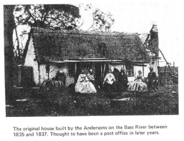
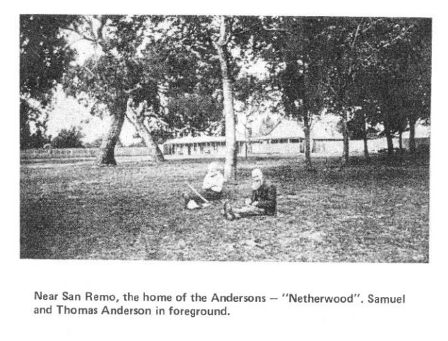
Samuel Anderson arrived in Hobart in 1834 and land-hungry like so many of his contemporaries, he looked to the southern part of Victoria for a place to settle. He was spurred on by the success of the Henty brothers at Portland, and that of Batman in Port Phillip Bay, and by their intention to defy the Government and “squat”. He and his partner Robert Massie set about acquiring a vessel and equipping it to search for suitable land in Western Port. In September 1835, they sailed into Western Port and, after investigation, decided to follow the route of George Bass along the Bass river, to the point where fresh water could be obtained, and there they settled.
Anderson was later joined by his two brothers, Hugh in 1837, and Thomas in 1841. They started the process of colonisation and in the next decade, the land around the shores of Western Port was acquired mostly by squatters or lease-holders. These hearty settlers showed that they were prepared to work to clear the land of the tea-tree and scrub and soon the district was supporting many families. Small towns started to grow – at Griffiths Point (now San Remo), Bass Landing, Queensferry, Grantville and Corinella. All of these were on the shores of the bay, because communication with the fast-growing Port of Melbourne was only possible by sea.
In his first year, Anderson is reputed to have planted commercial quantities of wheat, and a flour mill was constructed near the river at Bass Landing. This is generally believed to be the earliest flour mill in the State and one of the crushing stones from the mill, cut out of sandstone, is still in existence today at San Remo. Anderson and his partner soon discovered the wild cattle, progeny of the cattle left behind at the settlement of Corinella, and for the payment of 80 Pound to the Government in 1838, they acquired 70-80 head of these cattle.
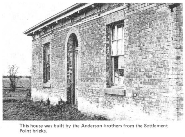
When the Corinella settlement was abandoned, thousands of bricks were neatly stacked ready for use. The early settlers helped themselves to these and to what other building materials they could salvage, and used them in the construction of their own dwellings. A derelict house still stands today at Bass, constructed of the bricks manufactured by the convicts. This house is reputed to have been built about 1840 by the Anderson brothers, but it was acquired by Michael Pender in the early 1840s and was the headquarters of the Upper Plains Run for many years.
The old settlement at Corinella became part of the Westaway Run, which was taken up in 1840 by George Westaway. In April 1844, the explorer Haydon, setting out from Corinella on a journey through Gippsland, was shown the remains of the settlement. In his report he stated that he saw a dam on the creek, the spacious verandah of, what had once been, Government House and the ruins of about fifty huts and houses.
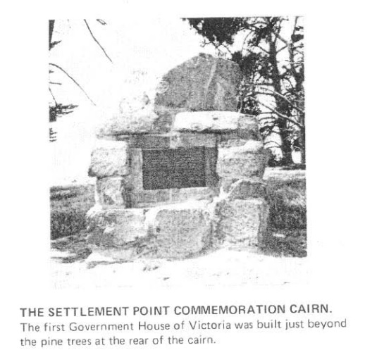
Today, nothing remains of the settlement, time has removed all traces of it; but close by is a stone cairn, the only visible reminder of the vain sweat and toil of the men and women, and the tantalising thoughts of what might have been.
SNIPPETS
FRENCH ISLAND: Named in 1800 by Captain Hamelin of the French ship “La Naturaliste”. A prison farm was established on the island in 1916, originally for youthful offenders, but later for men. The prison was close in 1974, and the buildings are being converted for a youth and recreation camp.
LONG ISLAND POINT: Originally surveyed in the 1850s as the township of Tyabb. This area is now the scene of great industrial development by Esso Petroleum, B.H.P., and Cresco Fertilizers.
HASTINGS: Named, it is believed, after the Marquis of Hastings. This fast-growing town was first settled by fishermen in the 1850s, and it was then known as Kings Creek. Prior to the coming of the railway in 1889, Hastings was served by coaches, and it was the original port for the early Phillip Island ferries.
SANDSTONE ISLAND: John Rogers of Churchill Island also held a pastoral license for this island in the 1850s and 60s. About this same time, the Acclimatisation Society of Victoria conducted experiments here with English birds, liberating pheasants, skylarks, and thrushes.
CRIB POINT: Named after a fisherman’s hut or “crib”. This area was first known as Morradoo, aboriginal for rainmaker. Latest development here is the B.P Refinery complex, and the oil wharf. Crib Point has developed into a very busy port, with the ever increasing number of oil tankers coming and going.
STONY POINT: Terminus of the Railway from 1892, and the present embarkation point for the Phillip Island and French Island ferry service.
FLINDERS NAVAL DEPOT: Known in naval circles as shore establishment “H.M.A.S. Cerberus”, established in 1912. This depot is located on the shores of Hann;s Inlet, which was named after Joseph Hann, who settled there in the early 1850s.
SAN REMO: Originally named Griffiths Point, after Captain Griffiths, the owner of the schooner “Elizabeth”, which sailed into Western Port in December 1833. Captain Hart was the master of the vessel, and the cargo that he was seeking was wattle bark. The name “San Remo” was chosen by the inhabitants, from the Italian town of San Remo, and the Government was petitioned to change the name. The Anderson brothers are buried in the San Remo cemetery.
QUEENSFERRY: Another once thriving coastal town. It declined when the railway line was built to Wonthaggi in 1910, and finally was destroyed and abandoned when a large tidal wave inundated the settlement in 1921.
GRANTVILLE: One of the largest of the original coastal towns relying on the sea trade. This settlement played an active part in the opening up of South Gippsland.